|
The R.C. Dening Collection |
 |
Introduction to Zambian Butterflies
by R.C. Dening F.R.E.S.
|
GENERAL |
| The first reports of
butterflies from Zambia are those of Butler, (1893 & 1895), from Lake Mweru and
Fwambo, near the southern end of Lake Tanganyika. A total of 72 species were recorded from
Lake Mweru and neighbouring areas, collected by R.Crawshay, and 31 from Fwambo, collected
by A.Carson. Strand (1909) recorded 42 species from Livingstone and the upper Zambezi
River, collected by F.Seiner. Neave (1910) published the results of two expeditions to
Zambia and southern Democratic Republic of Congo, recording 367 species of butterflies
from Zambia. Riley (1921) later listed 22 species from Solwezi and neighbouring districts,
collected by H.Dollman. There is a dearth of reports between 1921 and 1956, when White published a list recording 17 species of Papilionidae and 49 species of Pieridae. Pinhey (1962 & 1964) recorded 13 little known species collected on museum expeditions to Mwinilunga and the Copperbelt. Cottrell and Loveridge (1966) listed 89 species from Cryptosepalum woodland south of Mwinilunga. Pinhey and Loe (1977) discussed and illustrated 135 species in their "Guide to the Butterflies of Zambia", (also published under the title "Guide to the Butterflies of Central and Southern Africa") In recent times Heath (1977) recorded the life history of Pseudopontia paradoxa, Cottrell (1981) revised the Aslauga purpurascens complex, while G.A. & S.F.Henning (1988) reviewed the genus Capys, describing two new taxa from Zambia. Heath and Hancock have described several new taxa and discussed others from Zambia (Heath 1983, 1985; Hancock 1984a, b, 1985a, b, 1987, 1989, 1990, 1992; Hancock & Gardiner 1982; Hancock & Heath 1985, 1988). Collins & Larsen (1994) have described a new Skipper, Abantis bamptoni, while Dening (1995) summarised records of Abantis in Zambia and more recently, S.F. & G.A. Henning (1996) reviewed the genus Axiocerses and Heath (1997) reviewed the whole lycaenid tribe Aphnaeini. A feature of the Zambian situation has been the lack of a National Museum able to finance the continuous, efficient curation of collections. This has been an important reason for the absence of any earlier study of the fauna as a whole. Collections donated to the Livingstone Museum (e.g. by White), have largely disintegrated during periods of financial stringency. A further problem has been the widely dispersed nature of individual collections. However, the National Museum of Zimbabwe in Bulawayo has contributed very considerably over the years, and has to a large extent offset the deficiencies of the Livingstone Museum. The preparation of this checklist should not, therefore, be seen as the work of only a few individuals. A great many specialists and enthusiasts have contributed to our knowledge of the Zambian butterfly fauna, supplying specimens to major museums, informing each other, sometimes contributing to the literature. Individual contributions are discussed more fully in a later section on the history of butterfly recording in Zambia.
|
|
THE COUNTRY |

| Zambia became an independent
republic in 1964. Prior to that, it was known as the Territory of Northern Rhodesia,
administered by the British Colonial Office. Its boundaries were only fully demarcated at
the beginning of the century. It is a large country of some 753,000 square kilometres in south central Africa. On the north it is bounded by the Democratic Republic of the Congo (formerly Zaïre), in particular the Shaba Province, which includes Katanga. The Benguela Railway passes to the north of the border, probably explaining some locality labels on early museum specimens (not to be confused with Lake Bangweulu in the Luapula Province of northern Zambia). To the east the country is bounded by Tanzania, Malawi and Mozambique; to the south by Zimbabwe, Botswana and a small strip of Namibia; and to the west by Angola. In all, Zambia stretches through some ten degrees of latitude, from the borders of the Kalahari Desert at Sesheke in the south, to the tropical shores of Lake Tanganyika in the north. Zambia's current population is estimated at nine million, at least half of whom probably live in the urban areas. Its economy has hitherto depended largely on mining, although manufacturing is increasing, and agriculture has long contributed exports of tobacco, cotton, coffee and horticultural products. The staple urban food is maize, with a strong contribution from wheat flour; some of it made from local wheat. The rural staple in south, central and eastern areas is also maize. In the higher rainfall northern areas, wherever the soils are heavily leached, and indeed in other areas with difficult soil conditions, cassava is the staple crop. Commercial food crops of some importance, other than maize and wheat, are Soya and groundnuts. The current FAO Production Yearbook gives the following indication of land use (thousand hectares):
|
|
THE CLIMATE |

| The climate is largely
governed by the Inter Tropical Convergence Zone, which brings seasonal rainfall from the
northwest. This starts in September in Mwinilunga, but does not reach southern parts of
the country much before December. The reverse process starts in March, the rains not
leaving Mwinilunga before the beginning of May. Thus, the extreme northwest has a mere
four months dry season, while towards the south and east it may extend to nine months.
This influences the vegetation and the butterfly fauna. During the summer rains, average temperatures normally vary between 18ºC and 24ºC. It is during the dry season that extremes occur. As the rains move away dry southeasterly winds take their place. As mid-winter approaches these winds become colder so that, at the altitude of Lusaka, temperature may fall almost to freezing point. Then, as the sun moves south again, temperatures rise over the dry bare landscape. The trees are deciduous and lose their leaves during this dry season. By the end of September and in October shade temperatures may rise to 35ºC. Total rainfall decreases from north to south. On the Copperbelt for instance, it averages around 1,220mm, while in the Southern Province only 840mm can normally be expected, falling in some years to 630mm, or even to severe drought levels. A snapshot of weather factors at a particular Copperbelt site (Mufulira Mine) is given below. Mufulira Mine Site Conditions:
Sub tropical climate. Sandy or laterite soil conditions.
Altitude above sea level: 1,220 Metres. Mean barometric pressure 882 mbar
NATURAL PHENOMENA: Ambient dry bulb temperatures:
Relative humidity:
Wind velocity:
Precipitation:
Sunshine:
|
||||||||||||||||||||||||||||||||||||||||||||
|
PHYSICAL GEOGRAPHY |
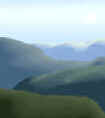
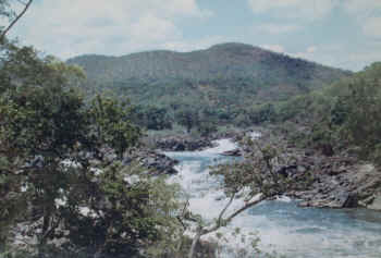
| Within the
above climatic parameters butterfly habitat variation is related to altitude, soils and
particularly in the north, the river systems (map here). The Congo River Basin The watershed defines much of the northern border, so that there is no direct contact between the riverine forests of the Congo and Zambia. All of the rivers and streams immediately to the north of the border fall within the catchment of the Lualaba River, which eventually becomes the Congo River. Hence evergreen riverine forest stretching back to the great central rainforest of Africa extends close to Zambia's northern border. Migration over the watershed by some of the more vigorous species, such as Charaxes, may well occur in many places. The Lualaba itself rises near the border; just north of Kansanshi Mine in Solwezi District, where also occurs one of the highest trigonometric points at 1,724 metres. The southernmost tributaries of the Lualaba extend, on the east, through Lake Mweru into Zambia, and up the Luapula River to its source in the Bangweulu Swamps; however, Lake Mweru largely breaks the evergreen forest chain. In the west, the longest tributary of the Lualaba extends right to the border of northwest Mwinilunga, a very short distance from the source of the Zambezi. However, the unusually rich evergreen forest fauna of the Kalene Hill pedicle of northwest Mwinilunga actually occurs on eastern tributaries of the Zambezi, which flow southwesterly into Angola, and has no direct connection with the Lualaba catchment. Much of the rest of the country lies on a plateau at an altitude of between 1,200 and 1,400 metres, falling gradually towards the southeast. On this plateau rise the three great rivers and their tributaries, which cut into the plateau and fall, sometimes through gorges, to the lowest points in Zambia. The Zambezi, Kafue and Luangwa Rivers Having its source in Mwinilunga at an altitude of approximately 1,370 metres, and having passed in a wide arc through Angola, the Zambezi re-emerges into the Barotse Plain, passes through dry sandy forests to the Victoria Falls, and on to Lake Kariba. Below the Kariba Dam, it is joined by the Kafue at an altitude of around 500 metres, and then by the Luangwa at Luangwa, (formerly Feira), at around 370 metres, the lowest point in Zambia. From here it flows through Mozambique to the sea.
The Luangwa rises in the high country to the east, near the Malawi border, at an elevation of about 1,400 metres. There it is fed by tributaries from the highest places in Zambia, the Makutu Mountains (1,850 metres), the Mafinga Mountains which lie astride the Malawi border at Chisenga (highest point 2,164 metres), and the borders of the Nyika Plateau. At the latter, only a small area falls within Zambia comprising the Chowo montane forest and associated montane grassland (altitude 2,000 metres).
|
Continue to